6 charts have been added in the GeoGarage platform :
- B238 Cat- Port Howe
- B274 New Providence West
- B284 North Bimini Anchorages
- B285 GB- Hall's Point Anchorage
- Northwest Bahamas (replacing BAH109 Bahamas)
- Southeast Bahamas (replacing BAH109 Bahamas)
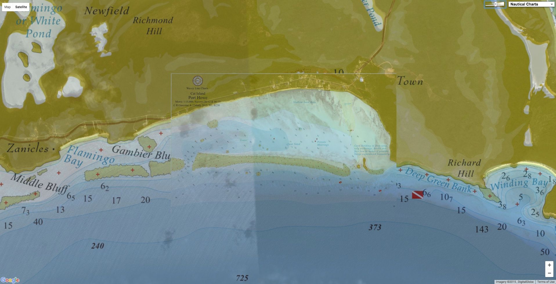
B238 Port Howe, Cat Island
a brand new chart in the Bahamas WLP layer
108 charts have been updated in the GeoGarage platform :
- B1 Georgeown
- B2 Stocking Holes
- B3 Ex- Jewfish
- B4 Kid Cove
- B5 Ex- Green Turtle
- B6 Ex- Hog Cay
- B7 Great Exuma
- B8 Ex-Pudding
- B9 Ex-Rat Cut
- B10 Ex- Soldier Cut
- B11 Ex- Rocky Pt.
- B13 Bimini Harbours
- B14 Gun Cay & Cat Cay
- B15 Chub Cay
- B19 Nassau Harbour
- B21 Cat Cat Club & Marina
- B23 Long Island - Clarence Town
- B32 Strangers Cut to Walkers Channel
- B33 Carters Cay to Fish Cays
- B34 Strangers Cay to Carters Cay
- B37 Ab- Allens Pen
- B39 Ab- Manjack Cay
- B42 Northwest Channel Light
- B43 Joulter's Cays Cut
- B56 GB - North Riding Rock
- B57 Rose Island - Bottom Harbour
- B59 Nassau, Eastern Approaches
- B60 Eleuthera - Fleeming Channel
- B61 New Providence - Lyford Cay Marina
- B79 Jumentos - Low Water Harbour
- B82 Jumentos - Ragged Island Harbour
- B94 Berry Islands Chart
- B96 Ber- Gt. Harbour Cay Marina
- B97 Ber- Gt, Harbour Cay
- B98 Ber- Hoffmano Little Harbour
- B99 Ber - Whale Cay to Frazer Hog Cay
- B100 Long Island - Cape Santa Maria to Stella Maris
- B101 Eleuthera - Runawayay Marina
- B102 Long Island - Clarenceown to Cape Verde
- B103 Long Island - Alligatoray
- B104 Long Island - Salt Pond
- B105 Long Island - Salt Pondo Clarenceown
- B106 Long Islando Little Exuma
- B107 Long Island - Nuevitas Rockso Conch Cay Harbour
- B108 Long Island - Conch Harbour & Dollar Harbour
- B110 Long Island - South Pt.
- B111 Long Island - Little Harbour
- B113 Gb- Indian Cay Cut
- B114 Gb- Oldahamaay Marina
- B118 Eleuthera - Egg Island Cut
- B119 Gb-Lucayan Waterway, South Entrance
- B120 Xanadu and Running Mon Marinas
- B122 Bimini Islands Chart
- B148 Grandahama Overall Chart
- B152 Ab- Powell Cay & Spanish Channel South
- B153 New Providence- Albany Marina
- B162 Ab- Fish Cays
- B167 GB- South Shore Hub
- B169 Gb- Port Lucaya & Grandahama Yacht Cllub
- B173 Whaleo Manjack - (Chartlet C)
- B177 Biminiay Resort & Casino
- B179 Green Turtle Reefs
- B182 Manjackanko Hog Cays - (Chartlet D)
- B190 Biminis Orange Cay
- B191 Hog Cays to Moraine Cay
- B195 Long Island- Stella Mariso Salt Pond
- B210 Jumentos- Flamingo Cay to Great Exuma
- B211 Jumentos- Man O War Cay to Nurse Channel
- B212 Jumentos- Nurse Cut to Nurse Cay
- B213 Jumentos - Water Cays
- B214 Jumentos- Nurse Cay to Raccoon Cay
- B215 Jumentos- Raccoon Cay to Johnson Cay
- B216 Jumentos- Johnson Cay to Hog Cay
- B217 Jumentos- Man O War Cays
- B218 Jumentos- Hog Cay to Ragged Is.
- B219 Jumentos- Ragged Island
- B220 Jumentos- Jamaica Cay
- B221 Jumentos- Pear Cay Pass
- B224 Jumentos - Flamingo Cay
- B225 Eleuthera - Spanish Wells & Devil's Backbone
- B226 Eleuthera - Royal island Hbr.
- B227 Northern Eleuthera
- B228 Central Eleuthera
- B229 Southern Eleuthera
- B230 Eleuthera- Devil's Backbone (Intricate Part)
- B231 Eleuthera- Harbour Island
- B232 Eleuthera- Harbour Mouth
- B236 Eleuthera- Governor's Harbour
- B241 Gb- Sandy Cay
- B242 Eleuthera- Davis Harbour
- B244 Eleuthera- Cape Eleuthera Marina
- B245 Cat- Cat Island Northwest & Lt. San Salvador
- B246 Cat- Cat Island Southeast
- B247 Cat- Sand Pt. to Orange Creek
- B248 Cat - Pigeon Creek
- B250 Cat - Fernandez Bay
- B251 Cat- The Bight
- B252 Cat- Hawksnest Area
- B253 Cat- Hawksnest Creek
- B256 Dollar Harbour
- B257 Bimini South Riding Rock
- B258 Gb- Lucayan Waterway, North Entrance
- B272 Cat- Bennetts Harbour
- B273 Eleuthera - Sail Rockso Finley Cay
- B276 Eleuthera- Tarpon Bay
- B281 Ex- The Marina at Emeralday
- B282 Eleuthera - Hatchet Bay
- B283 Eleuthera - Sail Rocks
Today 300 raster charts from Wavey Line Publishing (WLP) are included in the GeoGarage platform
These updates are automatically viewable on universal mobile applications :
- Weather 4D Android -App-in purchase mode- on the PlayStore
- Marine Bahamas WaveyLine iOS app on the AppStore