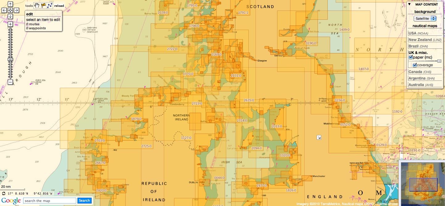
British Isles & miscellaneous other countries update
Today 1008 charts (1871 including insets)
are available in the 'British Isles & misc.' chart layer
This product has been derived in part from material obtained from the UK Hydrographic Office with the permission of the UK Hydrographic Office, Her Majesty’s Stationery Office, and the authorities of the following countries : British Isles (UK & Ireland), Croatia, Oman, Spain, Portugal, South Africa & Malta whose national Hydrographic Offices nautical maps are managed by UKHO
see acknowledgements
23 charts have been added since the previous update :
-
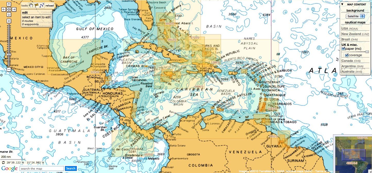
257 Harbours on the South Coast of Jamaica
- 454 Kingston Harbour
- 456 Approaches to Kingston Harbour
- 458 Port Antonio
- 464 Montego Bay and Ocho Rios Bay
- 607 Riviere Saloum
- 616 Approaches to Port Mombasa
- 617 Sherbro River
- 666 International Chart Series, Africa - East Coast, Kenya, Port Mombasa including Port Kilindini and Port Reitz
- 668 Lamu, Manda and Pate Bays and Approaches
- 702 Caribbean Sea - Nederlandse Antillenand Aruba, Aruba and Curacao
- 720 Grenada, Saint George's Harbour NEW chart
- 1412 Caribbean Sea - Nederlandse Antillen, Ports in Aruba and Curacao
- 1414 Bonaire
- 1457 International Chart Series, North Sea, Netherlands, Terschellinger Gronden to Harlingen.
- 1546 Zeegat van Texel and Den Helder Roads
- 1873 International Chart Series, North Sea, Dunkerque to Oostende
- 1874 International Chart Series, North Sea, Westerschelde, Oostende to Westkapelle
- 3778 United Arab Emirates, Ar Ruways and Jabal Az¸ Z¸annah NEW chart
- 3779 United Arab Emirates, Approaches to Ar Ruways and Jabal Az Zannah NEW chart
- 3780 United Arab Emirates, Outer Approaches to Ar Ruways and Jabal Az Zannah NEW chart
- 4137 Southern Africa - West Coast, Namibia, Walvis Bay Harbour NEW chart
- 4138 South Africa - West Coast, Namibia, Approaches to Walvis Bay NEW chart
and 3 charts have been withdrawn since the previous update :
- 472 West Indies, Dominican Republic and Puerto Rico, Mona Passage
- 2484 River Thames Hole Haven to London Bridge withdrawn and not replaced
- 4811 Mexico to Ecuador
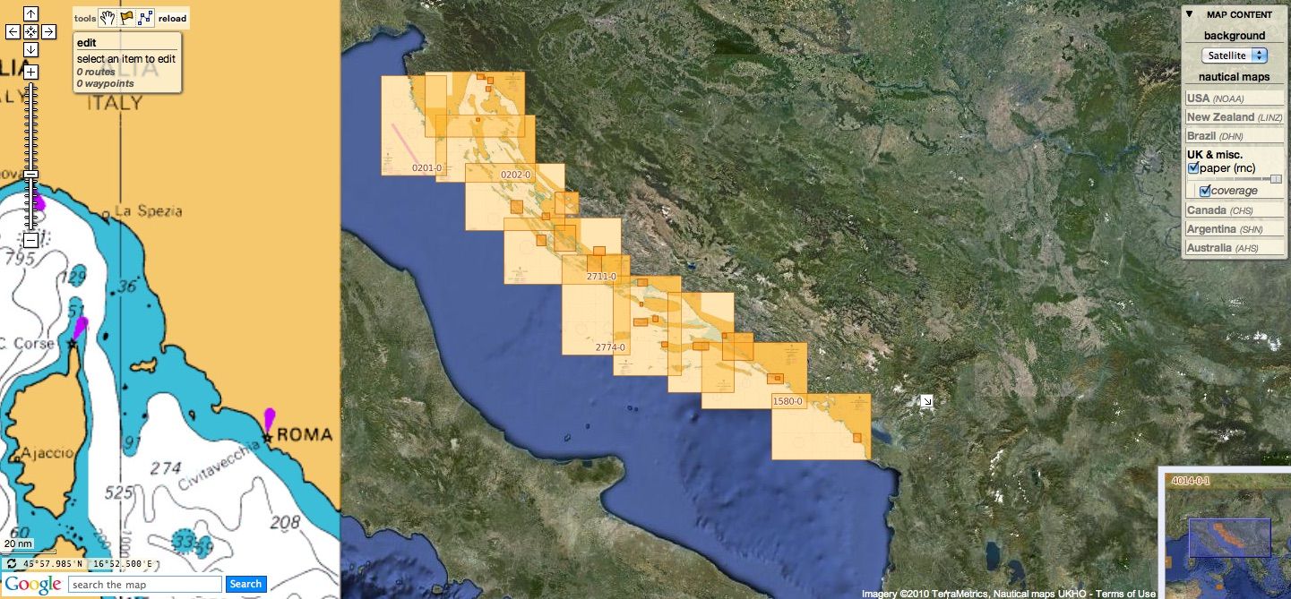
Croatia
14 charts
- 201 Rt Kamenjak to Novigrad
- 202 Kvarner, Kvarneric and Velebitski Kanal
- 269 Ploce and Split with Adjacent Harbours, Channels and Anchorages
- 515 Zadar to Luka Mali Losinj
- 680 Dubrovnik new edition
- 1574 Otok Glavat to Ploce and Makarska
- 1578 Croatia and Montenegro, Ulcinj to Boka Kotorska including Bar and Tivat
- 1580 Otocic Veliki Skolj to Otocic Glavat
- 1996 Ports in Rijecki Zaljev
- 2711 Rogoznica to Zadar
- 2712 Otok Susac to Split
- 2719 Rt Marlera to Senj including Approaches to Rijeka
- 2773 Sibenik, Pasmanski Kanal, Luka Telascica, Sedmovrace, Rijeka Krka
- 2774 Otok Vis to Sibenik
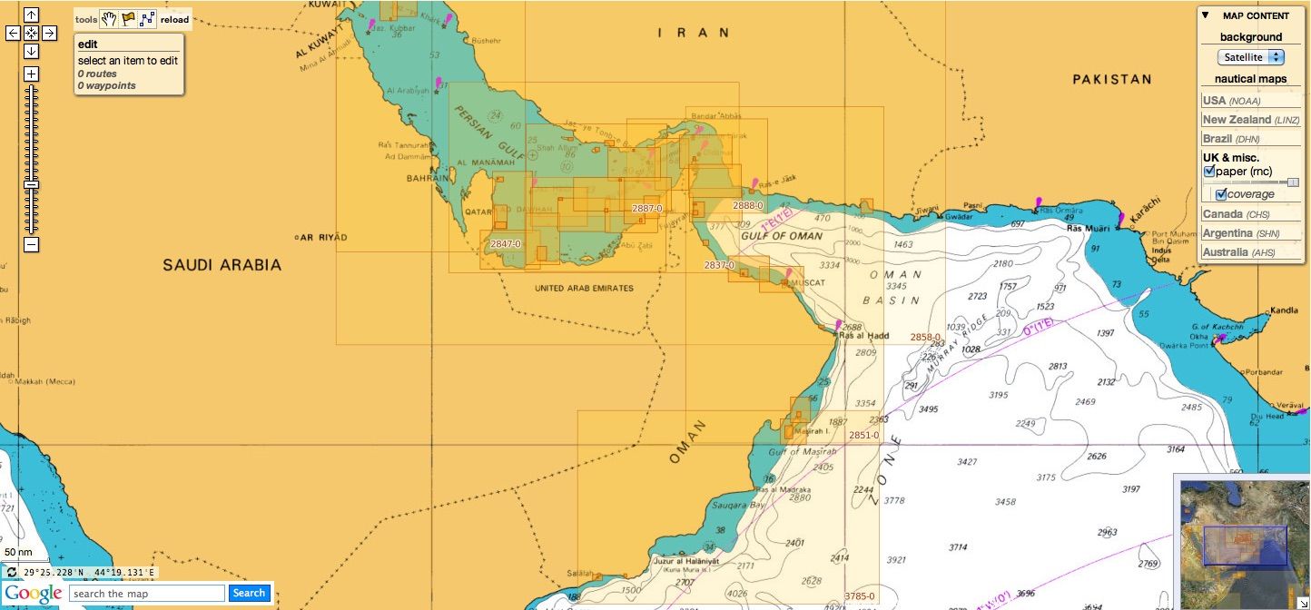
Oman
8 charts
- 2853 Gulf of Oman, approaches to Sohar
- 2854 Northern approaches to Masirah
-
2895 Arabia, Oman - South East Coast, Outer Approaches to Mina' Salalah (Mina' Raysut) new edition
-
3171 Southern Approaches to the Strait of Hormuz
- 3409 Plans in Iran, Oman and the United Arab Emirates
- 3511 Wudam and Approaches
- 3518 Ports and Anchorages on the North East Coast of Oman
- 3762 Oman - South East coast, Ad Duqm
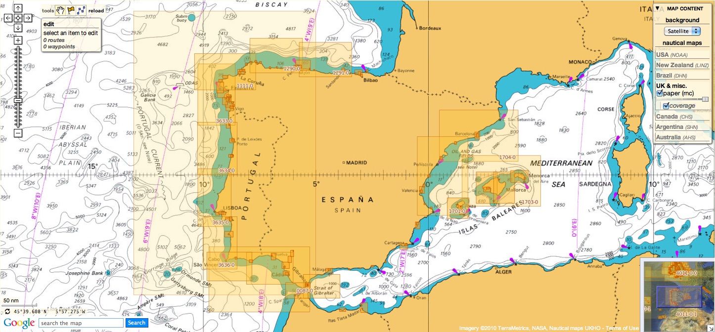
Spain & Portugal
162 charts
- 45 Mediterranean Sea, Gibraltar Harbour
- 73 Puerto de Huelva and Approaches
- 83 Ports on the South Coast of Portugal
- 86 Bahia de Cadiz
- 87 Cabo Finisterre to the Strait of Gibraltar
- 88 International Chart Series, Spain - South West Coast, Cadiz new edition
- 89 Cabo de Sao Vicente to Faro
- 91 Cabo de Sao Vicente to the Strait of Gibraltar
- 93 Cabo de Santa Maria to Cabo Trafalgar
- 142 Strait of Gibraltar
- 144 Mediterranean Sea, Gibraltar
- 307 Angola, Cabeca da Cobra to Cabo Ledo
- 308 Angola, Cabo Ledo to Lobito
- 309 Lobito to Ponta Grossa
- 310 Ponta Grossa to Kuene River
- 311 Gamba to Luanda new edition
- 312 Luanda to Baia dos Tigres
- 366 Arquipelago de Cabo Verde new edition
- 367 Ports in Arquipelago de Cabo Verde new edition
- 469 Alicante
- 473 Approaches to Alicante
- 518 Spain East Coast, Approaches to Valencia
- 562 Mediterranean Sea, Spain - East Coast, Valencia.
- 580 Al Hoceima, Melilla and Port Nador with Approaches
- 611 Cabo Roxo to Port Kamsar
- 647 Pemba (Porto Amelia)
- 649 Approaches to Nacala
- 650 Mozambique, Quelimane
- 659 International Chart Series, Angola, Port of Soyo and Approaches
- 690 Cabo Delgado to Mikindani Bay
- 773 Strait of Gibraltar to Isla de Alboran
- 774 Motril to Cartagena including Isla de Alboran
- 863 Plans on the North West Coast of Morocco
- 1003 Approaches to Porto da Beira
- 1094 Rias de Ferrol, Ares, Betanzos and La Coruna
- 1096 Ribadeo
- 1104 Bay of Biscay
- 1110 La Coruna and Approaches
- 1111 Punta de la Estaca de Bares to Cabo Finisterre
- 1117 Puerto de Ferrol
- 1118 Ria de Ferrol
- 1133 Ports on the Western Part of the North Coast of Spain
- 1142 Ria de Aviles new edition
- 1145 Spain - North Coast, Santander
- 1147 International Chart Series, Africa - West Coast, Cabo Roxo to Monrovia
- 1153 Approaches to Gijon
- 1154 Spain, north coast, Gijon
- 1157 Spain - North Coast, Pasaia (Pasajes) and Approaches
- 1170 Baie de Fontarabie or Rada de Higuer and Saint-Jean-de-Luz
- 1172 Puertos de Bermeo and Mundaka
- 1173 Spain - North Coast, Bilbao
- 1174 Approaches to Bilbao
- 1180 International Chart Sea, Mediterranean Sea , Spain - East Coast, Barcelona
- 1189 Approaches to Cartagena
- 1193 Spain - east coast, Tarragona
- 1194 Cartagena
- 1196 Approaches to Barcelona
- 1197 Plans on the West Coast of Africa
- 1215 Africa - West Coast, Plans on the Coast of Angola
- 1290 Cabo de San Lorenzo to Cabo Ortegal
- 1291 Santona to Gijon
- 1292 Mimizan-Plague to Cabo de Ajo
- 1356 Bahia de Corisco to Estuaire du Gabon
- 1387 Calabar to Bata including Isla de Bioko
- 1448 Gibraltar Bay
- 1453 Gandia
- 1455 Algeciras
- 1460 Sagunto
- 1514 International Chart Series, Mediterranean Sea, Spain - East Coast, Castellon
- 1515 Ports on the East Coast of Spain
- 1589 Almeria
- 1595 Ilhas do Principe, de Sao Tome and Isla Pagalu
- 1664 Riviere Saloum to Ilheu de Caio
- 1684 Ilha da Madeira, Manchico and Canical
- 1685 Ilha de Madeira, Ponta Gorda de Sao Lourenco including the Port of Funchal
- 1689 Ports in the Arquipelago da Madeira
- 1690 Plans on the North-West Coast of Africa
- 1699 Africa - West Coast, Nouadhibou
- 1700 Cartagena to Cabo de San Antonio including Isla Formentera
- 1701 Cabo de San Antonio to Vilanova I la Geltru including Islas de Ibiza and Formentera
- 1702 Ibiza, Formentera and Southern Mallorca
- 1703 Mediterranean Sea, Islas Beleares, Mallorca and Menorca
- 1704 Mediterranean Sea, Spain - East Coast, Punta de la Bana to Islas Medas
- 1705 Mediterranean Sea, Spain - France, Cabo San Sebastian to Iles D'Hyeres
- 1724 Canal do Geba and Bissau
- 1726 Approaches to Canal do Geba and Rio Cacheu
- 1727 Guinea - Bissau, Bolama and Approaches
- 1730 Spain - West Coast, Ria de Vigo
- 1731 Vigo
- 1732 Spain - West Coast, Ria de Pontevedra
- 1733 Spain - West Coast, Marin and Pontevedra
- 1734 Approaches to Ria de Arousa
- 1740 Livingston Island, Bond Point to Brunow Bay including Juan Carlos 1 Base and Half Moon Island
- 1755 Plans in Ria de Arousa
- 1756 Ria de Muros
- 1762 Vilagarcia de Arosa
- 1764 Ria de Arousa
- 1831 Arquipelago da Madeira
- 1847 Santa Cruz de Tenerife
- 1850 Approaches to Malaga
- 1851 Malaga
- 1854 Motril and Adra new edition
- 1856 Approaches to Puerto de La Luz (Las Palmas)
- 1858 Approaches to Santa Cruz de Tenerife, Puerto de San Sebastian de la Gomera, Santa Cruz de la Palma and Approaches
- 1861 North Atlantic Ocean – Islas Canarias, Gran Canaria to El Hierro
- 1862 North Atlantic Ocean – Islas Canarias, Lanzarote to Cabo Bojador
- 1863 Islas Canarias, Puerto de los Marmoles to Puerto del Rosario
- 1895 Ilha de Sao Miguel
- 1912 Ports on the North and West Coasts of Morocco
- 1950 Arquipelago dos Acores
- 1956 Arquipelago dos Acores, Central Group
- 1957 Harbours in the Arquipelago Dos Acores (Central Group)
- 1959 Flores,Corvo and Santa Maria with Banco Das Formigas
- 2437 Ras Tarf to Oran
- 2717 Strait of Gibraltar to Barcelona and Alger including Islas Baleares
- 2742 Cueta
- 2758 Africa, East Coast, Mozambique, Porto da Beira
- 2761 Menorca
- 2762 Menorca, Mahon
- 2831 Punta Salinas to Cabo de Formentor including Canal de Menorca
- 2832 Punta Salinas to Punta Beca including Isla de Cabrera
- 2834 Ibiza and Formentera
- 2927 Pemba to Mtwara
- 2932 Cabo de Sao Sebastiao to Beira
- 2934 Africa - east coast, Mozambique, Beira to Rio Zambeze
- 2935 Quelimane to Ilha Epidendron
- 2976 Spain - South West Coast, Approaches to Rio Guadalquivir. Rio Guadalquivir, Bonanza to Salina de Santa Teresa.
- 2977 Rio Guadalquivir - Cano de Enriquez to Cano de San Carlos
- 2978 Spain - South West Spain, Rio Guadalquivir - Cano de San Carlos to Punta de la Lisa
- 2979 Spain - South West Coast, Rio Guadalquivir - Punta de La Lisa to Coria del Rio
- 2980 Spain - South West Coast, Rio Guadalquivir, Huerta del Rincon to Sevilla
- 3034 Approaches to Palma
- 3035 Palma
- 3118 International Chart Series, Africa - West Coast, Lagos to Gamba
- 3132 Strait of Gibraltar to Arquipelago da Madeira
- 3133 Casablanca to Islas Canarias (Including Arquipelago da Madeira)
- 3134 Africa - West Coast, Islas Canarias to Nouakchott
- 3135 Nouakchott to Bissau and Arquipelago de Cabo Verde
- 3220 Entrance to Rio Tejo including Baia de Cascais
- 3221 Lisboa, Paco de Arcos to Terreiro do Trigo
- 3222 Lisboa, Alcantara to Canal do Montijo
- 3224 Approaches to Sines
- 3227 Aveiro and Approaches
- 3228 International Chart Series, Portugal - West Coast, Approaches to Figueira da Foz
- 3257 Viana do Castelo and Approaches
- 3258 Approaches to Leixoes and Barra do Rio Douro
- 3259 Approaches to Setubal
- 3260 Carraca to Ilha do Cavalo
- 3327 Kelibia to Tarabulus
- 3448 Plans in Angola
- 3578 Eastern Approaches to the Strait of Gibraltar
- 3633 Islas Sisargas to Rio Mino
- 3634 Montedor to Cabo Mondego
- 3635 Cabo Mondego to Cabo Espichel
- 3636 Cabo Espichel to Cabo de Sao Vicente
- 3764 Cabo Torinana to Punta Carreiro
- 3878 International Chart Series, Indian Ocean, Mozambique Channel, Central Part
- 3880 International Chart Series, Indian Ocean, Mozambique Channel, Southern Part
- 4114 Arquipelago dos Acores to Flemish Cap
- 4115 Arquipelago dos Acores to the Arquipelago de Cabo Verde
- 4742 Harbours on the North Coast of Spain
- 4743 Ports on the North Coast of Spain
- 4744 Spain - North Coast, Ensenada de San Ciprian
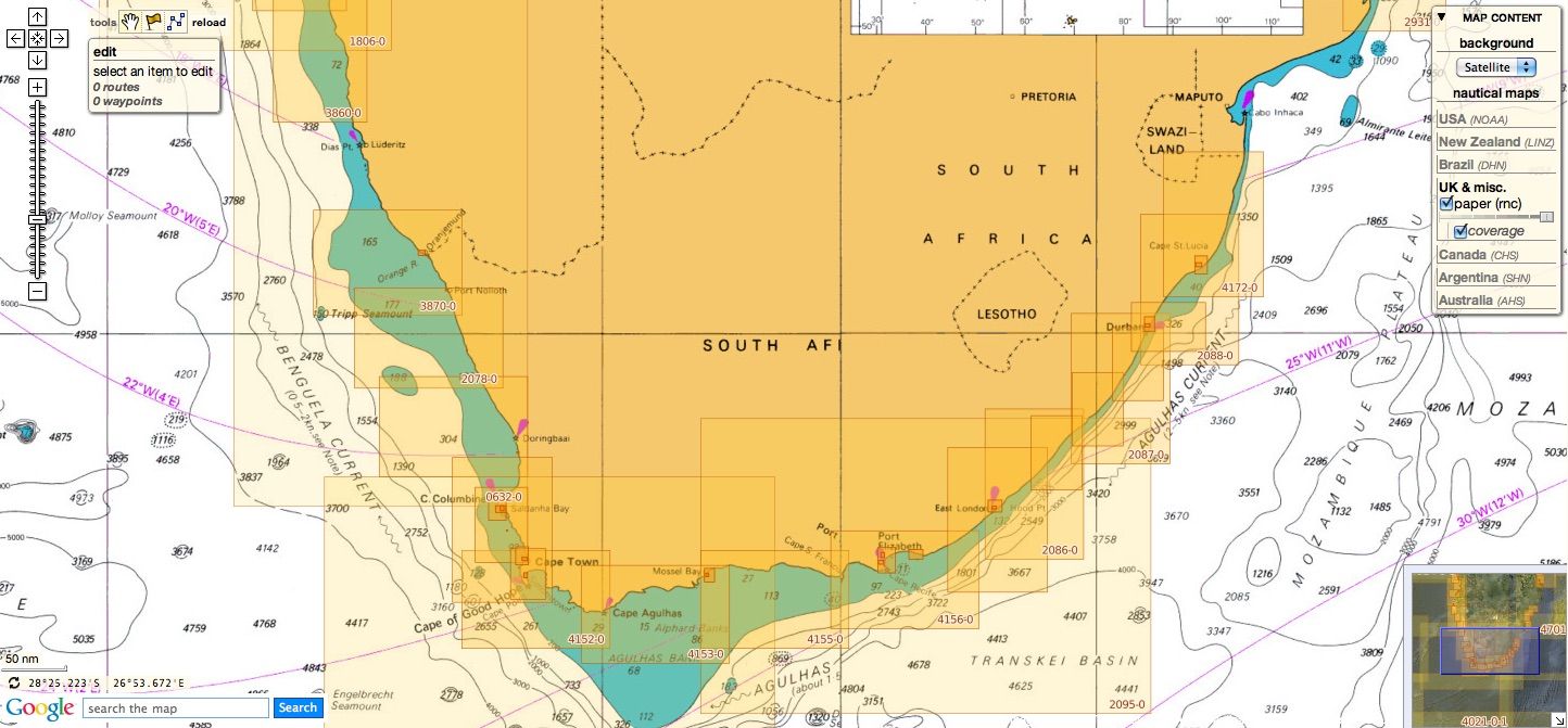
South Africa
53 charts
- 310 Ponta Grossa to Kuene River
- 643 Durban Harbour
- 665 Approaches to Zanzibar
- 1236 Saldanha Bay
- 1846 Table Bay Docks and Approaches
- 1922 RSA - Simon's Bay
- 2078 Port Nolloth to Island Point
- 2930 Jesser Point to Boa Paz
- 3211 Zanzibar Harbour
- 3300 Mbashe Point to Maputo
- 3793 Shixini Point to Port S Johns new edition
- 3794 Port S Johns to Port Shepstone new edition
- 3795 Port Shepstone to Cooper Light new edition
- 3797 Green Point to Tongaat Bluff new edition
- 3859 Cape Cross to Conception Bay
- 3860 Mutzel Bay to Spencer Bay
- 3861 Namibia, Approaches to Luderitz
- 3869 Hottentot Point to Chamais Bay
- 3870 Chamais Bay to Port Nolloth
- 4132 Kunene River to Sand Table Hill
- 4133 Sand Table Hill to Cape Cross
- 4136 Harbours on the West Coasts of Namibia and South Africa
- 4137 Southern Africa - West Coast, Namibia, Walvis Bay Harbour NEW chart
- 4138 South Africa - West Coast, Namibia, Approaches to Walvis Bay NEW chart
- 4141 Island Point to Cape Deseada
- 4142 Saldanha Bay Harbour
- 4145 Approaches to Saldanha Bay
- 4146 Cape Columbine to Table Bay
- 4148 Approaches to Table Bay
- 4150 Republic of South Africa, South West Coast, Table Bay to Valsbaai
- 4151 Cape Deseada to Table Bay
- 4152 Republic of South Africa, South West Coast, Table Bay to Cape Agulhas
- 4153 Republic of South Africa, South Coast, Cape Agulhas to Cape St. Blaize
- 4154 Mossel Bay
- 4155 Cape St Blaize to Cape St Francis
- 4156 South Africa, Cape St Francis to Great Fish Point
- 4157 South Africa, Approaches to Port Elizabeth
- 4158 Republic of South Africa - South Coast, Plans in Algoa Bay.
- 4159 Great Fish Point to Mbashe Point
- 4160 Ngqura Harbour
- 4162 Approaches to East London
- 4163 Republic of South Africa, South East Coast, Mbashe Point to Port Shepstone
- 4169 Republic of South Africa - East Coast, Approaches to Durban Oil Terminal SBM
- 4170 Approaches to Durban
- 4171 Republic of South Africa – South East Coast, Port Shepstone to Tugela River.
- 4172 Tugela River to Ponta do Ouro
- 4173 Approaches to Richards Bay
- 4174 Richards Bay Harbour
- 4175 International Chart Series, Angola and Namibia, Baia Dos Tigres to Walvis Bay
-
4176 International Chart Series, Namibia and South Africa, Walvis Bay to Orange River
-
4177 International Chart Series, Namibia and South Africa, Orange River to Table Bay
-
4178 International Chart Series, Republic of South Africa - South Coast,Table Bay to East London NEW chart
-
4179 International Chart Series, Republic of South Africa - East Coast ,East London to Richards Bay NEW chart4204 Walvis Bay to Maputo
- 4205 Agulhas Plateau to Discovery Seamounts
Malta
5 charts
- 36 Marsaxlokk
- 177 Valletta Harbours
- 211 Plans in the Maltese Islands
- 2537 Ghawdex (Gozo), Kemmuna (Comino) and the Northern Part of Malta
- 2538 Malta
NGA
50 international charts
- 3 Chagos Archipelago
- 82 Outer Approaches to Port Sudan
- 100 Raas Caseyr to Suqutra
- 255 Eastern Approaches to Jamaica
- 256 Western Approaches to Jamaica
- 260 Pedro Bank to the South Coast of Jamaica
- 333 Offshore Installations in the Gulf of Suez
- 334 North Atlantic Ocean, Bermuda
- 386 Yadua Island to Yaqaga Island
- 390 Bahamas, Grand Bahama Island, Approaches to Freeport
- 398 Grand Bahama Island, Freeport Roads, Freeport Harbour
- 447 International Chart Series, Antarctica - Graham Land, Pendleton Strait and Grandidier Channel
- 457 Portland Bight
- 462 The Cayman Islands
- 501 South East Approaches to Trinidad
- 920 Chagos Archipelago, Diego Garcia
- 928 Sulu Archipelago
- 959 Colson Point to Belize City including Lighthouse Reef and Turneffe Islands
- 1043 Saint Lucia to Grenada and Barbados
- 1265 Approaches to Shatt Al 'Arab or Arvand Rud, Khawr Al Amaya and Khawr Al Kafka
- 1266 South-Eastern Portion of the Bahama Islands
- 1450 Turks and Caicos Islands, Turks Island Passage and Mouchoir Passage
- 2133 Approaches to Suez Bay (Bahr el Qulzum)
- 2373 Bahr el Qulzum (Suez Bay) to Ras Sheratib
- 2374 Ra's Sharatib to Juzur Ashrafi
- 2658 Outer Approaches to Mina` al Jeddah (Jiddah)
- 2837 Strait of Hormuz to Qatar
- 2975 International Chart Series, Antarctica - Graham Land, Matha Strait to Larrouy Island
- 3043 Red Sea, Ports on the coast of Egypt.
- 3175 Jazirat al Hamra' to Dubai (Dubayy) and Jazireh-ye Sirri
- 3179 UAE and Qatar, Jazirat Das to Ar Ru' Ays
- 3310 Africa - east coast, Mafia Island to Pemba Island
- 3361 Wasin Island to Malindi
- 3432 Saltpond to Tema
- 3493 Red Sea - Sudan, Bashayer Oil Terminals and Approaches.
- 3519 Southern Approaches to Masirah
- 3520 Khawr Kalba and Dawhat Diba to Gahha Shoal
- 3522 Approaches to Masqat and Mina' al Fahl
- 3530 Approaches to Berbera
- 3709 Gulf of Oman, United Arab Emirates, Port of Fujairah (Fujayrah) and Offshore Terminals.
- 3723 Gulf of Oman, United Arab Emirates, Approaches to Khawr Fakkan and Fujairah (Fujayrah)
- 3779 United Arab Emirates, Approaches to Ar Ruways and Jabal Az Zannah NEW chart
-
3780 United Arab Emirates, Outer Approaches to Ar Ruways and Jabal Az¸Zanna NEW chart
- 3785 Mina' Raysut to Al Masirah
- 3907 Bahama Islands and Hispaniola, Passages between Mayaguana Island and Turks and Caicos Islands.
- 3908 Passages between Turks and Caicos Islands and Dominican Republic
- 3910 Little Bahama Bank including North West Providence Channel
- 3912 Bahamas, North East Providence Channel and Tongue of the Ocean
- 3913 Bahamas, Crooked Island Passage and Exuma Sound
- 3914 Turks and Caicos Islands and Bahamas, Caicos Passage and Mayaguana Passage
Don't forget to visit the UKHO Notices to Mariners : NTM for 2018