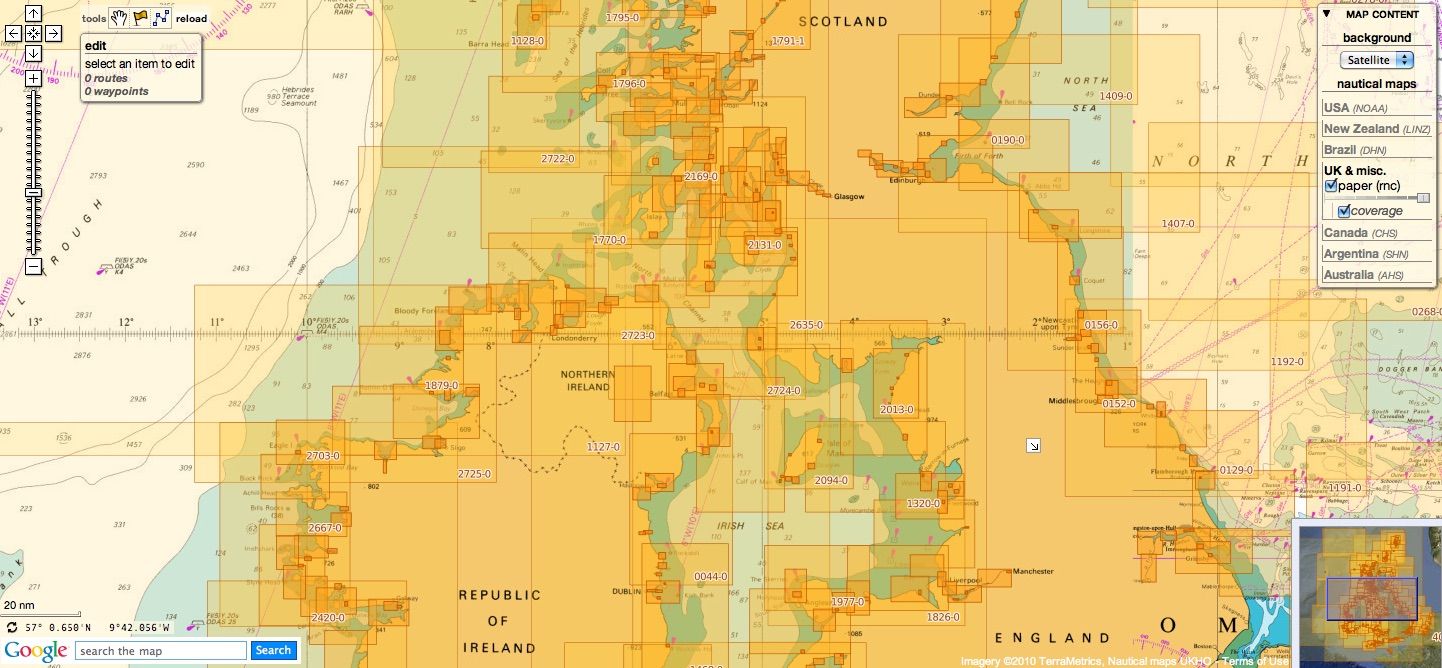
British Isles & miscellaneous other countries update
Today 959 charts (1787 including insets)
are available in the 'British Isles & misc.' chart layer
This product has been derived in part from material obtained from the UK Hydrographic Office with the permission of the UK Hydrographic Office, Her Majesty’s Stationery Office, and the authorities of the following countries : British Isles (UK & Ireland), Oman, Portugal, South Africa & Malta whose national Hydrographic Offices nautical maps are managed by UKHO
see acknowledgements
13 charts have been added since the previous update :
780 Caribbean Sea, Bonaire
1406 North Sea, Dover and Calais to Orford Ness and Scheveningen
1414 Bonaire
1630 International Chart Series, North Sea, Netherlands, West Hinder and Outer Gabbard to Vlissingen and Scheveningen
1872 North Sea, Dunkerque to Vlissingen
1873 International Chart Series, North Sea, Dunkerque to Oostende
1874 International Chart Series, North Sea, Westerschelde, Oostende to Westkapelle
2449 North Sea, Dover Strait to Westerschelde
2851 Arabian Sea and Gulf of Oman, Masirah to the Strait of Hormuz
3171 Gulf of Oman, Iran, Oman and United Arab Emirates, Southern Approaches to the Strait of Hormuz
3520 International Chart Series, Gulf of Oman, United Arab Emirates, Iran and Oman, Khawr Kalba and Dawhat Diba to Gahha Shoal
3776 International Chart Series, Saudi Arabia, Ra's al Ju`aymah Terminals
4624 Santa Cruz Islands to Butaritari
|
|
Portugal
59 charts
- 83 Ports on the South Coast of Portugal
- 87 Spain and Portugal, Cabo Finisterre to the Strait of Gibraltar
- 89 Portugal - South Coast, Cabo de Sao Vicente to Faro
- 91 International Chart Series, Cabo de Sao Vicente to the Strait of Gibraltar
- 93 Cabo de Santa Maria to Cabo Trafalgar
- 307 International Chart Series, Angola - Cabeca da Cobra to Cabo Ledo
- 308 Angola, Cabo Ledo to Lobito
- 309 Lobito to Ponta Grossa
- 311 International Chart Series, Gabon, Congo, Angola and Congo (Democratic Republic), Gamba to Luanda
- 312 Luanda to Baia dos Tigres
- 366 North Atlantic Ocean, Arquipelago de Cabo Verde
- 367 North Atlantic Ocean, Ports in Cabo Verde
- 611 Cabo Roxo to Port Kamsar
- 659 International Chart Series, Angola, Port of Soyo and Approaches
- 690 Cabo Delgado to Mikindani Bay
- 1147 International Chart Series, Africa - West Coast, Cabo Roxo to Monrovia
- 1197 Plans on the West Coast of Africa
- 1215 Africa - West Coast, Plans on the Coast of Angola
- 1595 Gulf of Guinea, Ilhas Do Principe, De Sao Tome and Isla De Annobon
- 1664 Riviere Saloum to Ilheu de Caio
- 1684 Ilha da Madeira, Manchico and Canical
- 1685 Ilha de Madeira, Ponta Gorda de Sao Lourenco including the Port of Funchal
- 1724 Canal do Geba and Bissau
- 1726 Approaches to Canal do Geba and Rio Cacheu
- 1727 Guinea - Bissau, Bolama and Approaches
- 1831 Arquipelago da Madeira
- 1895 Ilha de Sao Miguel
- 1950 Arquipelago dos Acores
- 1956 Arquipelago dos Acores, Central Group
- 1957 Harbours in the Arquipelago Dos Acores (Central Group)
- 1959 Flores,Corvo and Santa Maria with Banco Das Formigas
- 2932 Cabo de Sao Sebastiao to Beira
- 2934 Africa - east coast, Mozambique, Beira to Rio Zambeze
- 2935 Quelimane to Ilha Epidendron
- 3118 International Chart Series, Africa - West Coast, Lagos to Gamba
- 3132 Portugal, Spain and Morocco, Strait of Gibraltar to Arquipelago da Madeira
- 3133 Casablanca to Islas Canarias (Including Arquipelago da Madeira)
- 3135 North Atlantic Ocean, Nouakchott to Bissau and Arquipelago de Cabo Verde
- 3220 Entrance to Rio Tejo including Baia de Cascais
- 3221 Lisboa, Paco de Arcos to Terreiro do Trigo
- 3222 Lisboa, Alcantara to Canal do Montijo
- 3224 Approaches to Sines
- 3227 Aveiro and Approaches
- 3228 International Chart Series, Portugal - West Coast, Approaches to Figueira da Foz
- 3257 Viana do Castelo and Approaches
- 3258 Approaches to Leixoes and Barra do Rio Douro
- 3259 Approaches to Setubal
- 3260 Carraca to Ilha do Cavalo
- 3291 Angola, (Cabinda), Cabinda and Malongo Terminals
- 3327 Bata to Libreville including Ilhas do Principe and de Sao Tome
- 3448 Plans in Angola
- 3633 Islas Sisargas to Rio Mino
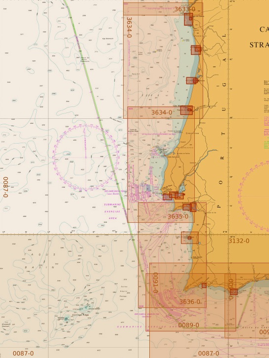
- 3634 Montedor to Cabo Mondego
- 3635 Portugal - West Coast, Cabo Mondego to Cabo Espichel
- 3636 Portugal - West Coast, Cabo Espichel to Cabo de Sao Vicente
- 3878 International Chart Series, Indian Ocean, Mozambique Channel, Central Part
- 3880 International Chart Series, Indian Ocean, Mozambique Channel, Southern Part
- 4114 Arquipelago dos Acores to Flemish Cap new edition
- 4115 Arquipelago dos Acores to the Arquipelago de Cabo Verde
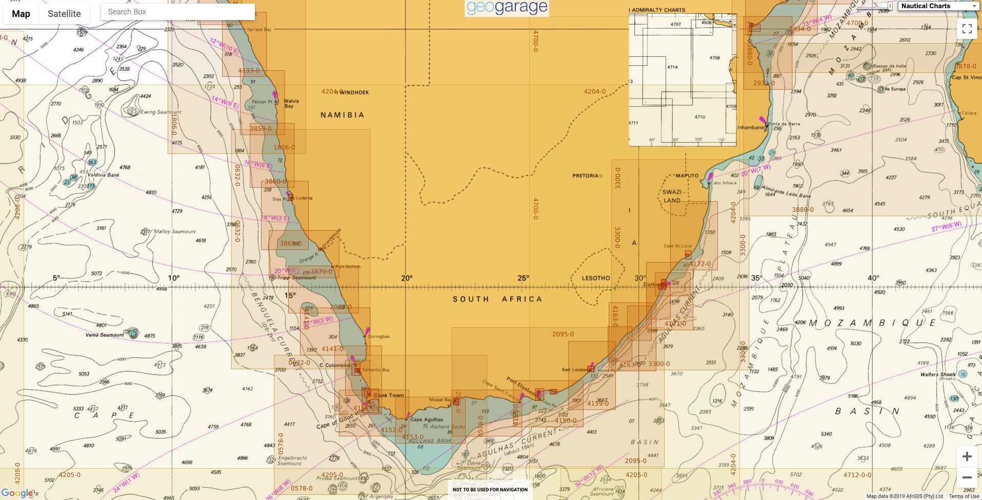
South Africa
53 charts
- 310 Ponta Grossa to Kuene River
- 643 Durban Harbour
- 665 Approaches to Zanzibar
- 1236 Saldanha Bay
- 1846 Table Bay Docks and Approaches
- 1922 RSA - Simon's Bay
- 2078 Port Nolloth to Island Point new edition
- 2930 Jesser Point to Boa Paz
- 3211 Zanzibar Harbour
- 3300 Mbashe Point to Maputo
- 3793 Shixini Point to Port S Johns
- 3794 Port S Johns to Port Shepstone
- 3795 Port Shepstone to Cooper Light
- 3797 Green Point to Tongaat Bluff
- 3859 Cape Cross to Conception Bay
- 3860 Mutzel Bay to Spencer Bay
- 3861 Namibia, Approaches to Luderitz
- 3869 Hottentot Point to Chamais Bay
- 3870 Chamais Bay to Port Nolloth new edition
- 4132 Kunene River to Sand Table Hill
- 4133 Sand Table Hill to Cape Cross
- 4136 Harbours on the West Coasts of Namibia and South Africa
- 4141 Island Point to Cape Deseada new edition
- 4142 Saldanha Bay Harbour
- 4145 Approaches to Saldanha Bay
- 4146 Cape Columbine to Table Bay new edition
- 4148 Approaches to Table Bay new edition
- 4150 Republic of South Africa, South West Coast, Table Bay to Valsbaai new edition
- 4151 Cape Deseada to Table Bay new edition
- 4152 Republic of South Africa, South West Coast, Table Bay to Cape Agulhas new edition
- 4153 Republic of South Africa, South Coast, Cape Agulhas to Cape St. Blaize new edition
- 4154 Mossel Bay
- 4155 Cape St Blaize to Cape St Francis new edition
- 4156 South Africa, Cape St Francis to Great Fish Point new edition
- 4157 South Africa, Approaches to Port Elizabeth
- 4158 Republic of South Africa - South Coast, Plans in Algoa Bay.
- 4159 Great Fish Point to Mbashe Point new edition
- 4160 Ngqura Harbour
- 4162 Approaches to East London
- 4163 Republic of South Africa, South East Coast, Mbashe Point to Port Shepstone new edition
- 4169 Republic of South Africa - East Coast, Approaches to Durban Oil Terminal SBM
- 4170 Approaches to Durban new edition
- 4171 Republic of South Africa – South East Coast, Port Shepstone to Tugela River. new edition
- 4172 Tugela River to Ponta do Ouro new edition
- 4173 Approaches to Richards Bay
- 4174 Richards Bay Harbour
- 4175 International Chart Series, Angola and Namibia, Baia Dos Tigres to Walvis Bay
-
4176 International Chart Series, Namibia and South Africa, Walvis Bay to Orange River
-
4177 International Chart Series, Namibia and South Africa, Orange River to Table Bay
-
4178 International Chart Series, Republic of South Africa - South Coast,Table Bay to East London
-
4179 International Chart Series, Republic of South Africa - East Coast ,East London to Richards Bay
-
4204 Walvis Bay to Maputo
- 4205 Agulhas Plateau to Discovery Seamounts
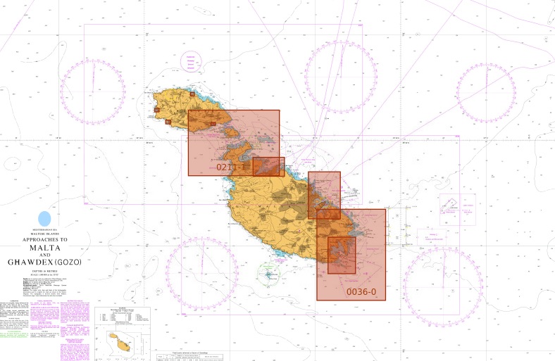
Malta
5 charts
- 36 Marsaxlokk
- 177 Valletta Harbours
- 211 Plans in the Maltese Islands
- 2537 Ghawdex (Gozo), Kemmuna (Comino) and the Northern Part of Malta
- 2538 Malta
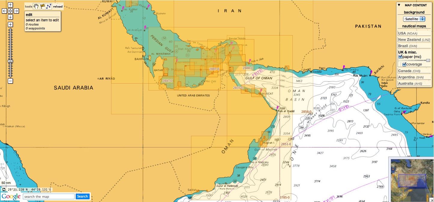
Oman
9 charts
- 2853 Gulf of Oman, Approaches to Sohar
- 2854 Northern approaches to Masirah
- 2895 Arabia, Oman - South East Coast, Outer Approaches to Mina' Salalah (Mina' Raysut)
- 3171 Gulf of Oman, Iran, Oman and United Arab Emirates, Southern Approaches to the Strait of Hormuz new chart
- 3409 Plans in Iran, Oman and the United Arab Emirates
- 3511 Oman, Said Bin Sultan Naval Base and Approaches
- 3518 Gulf of Oman, Ports and Anchorages on the North East Coast of Oman
- 3762 Oman - South East Coast, Ad Duqm
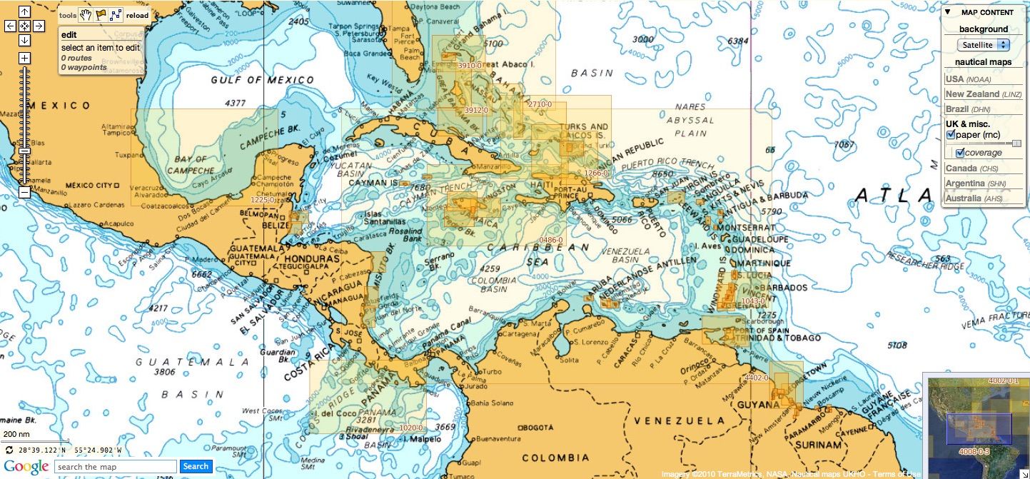
NGA
46 international charts
- 3 International Chart Series, Indian Ocean, British Indian Ocean Territory, Chagos Archipelago
- 82 Outer Approaches to Port Sudan
- 100 International Chart Series, Africa - East Coast, Gees Gwardafuy (Raas Caseyr) to Suqutra (Socotra)
- 255 Eastern Approaches to Jamaica
- 256 Western Approaches to Jamaica
- 260 Pedro Bank to the South Coast of Jamaica
- 333 Offshore Installations in the Gulf of Suez
- 334 North Atlantic Ocean, Bermuda
- 386 Yadua Island to Yaqaga Island
- 390 Bahamas, Grand Bahama Island, Approaches to Freeport
- 398 Bahamas - Grand Bahama Island, Freeport Roads
- 447 International Chart Series, Antarctica - Graham Land, Pendleton Strait and Grandidier Channel
- 462 West Indies, The Cayman Islands
- 501 South East Approaches to Trinidad
- 920 Chagos Archipelago, Diego Garcia
- 928 Sulu and Celebes Seas, Sulu Archipelago
- 959 Colson Point to Belize City including Lighthouse Reef and Turneffe Islands
- 1043 Saint Lucia to Grenada and Barbados
- 1265 Approaches to Shatt Al 'Arab or Arvand Rud, Khawr Al Amaya and Khawr Al Kafka
- 1450 Turks and Caicos Islands, Turks Island Passage and Mouchoir Passage
- 2133 International Chart Series, Red Sea - Egypt, Gulf of Suez, Approaches to Suez Bay (Bahr Al Qulzum)
- 2373 International Chart Series, Red Sea - Egypt, Gulf of Suez, Suez Bay (Bahr el Qulzum) to Ra's Sharatib
- 2374 International Chart Series, Red Sea - Egypt, Gulf of Suez, Ra's Sharatib to Juzur Ashrafi
- 2658 International Chart Series, Red Sea, Saudi Arabia, Outer Approaches to Jeddah (Mina` al Jiddah)
- 2837 Strait of Hormuz to Qatar
- 2975 International Chart Series, Antarctica - Graham Land, Matha Strait to Larrouy Island
- 3175 International Chart Series, United Arab Emirates and Iran, Jazirat al Hamra' to Dubai (Dubayy) and Jazireh-Ye Sirri
- 3179 International Chart Series, UAE and Qatar, Jazirat Das to Ar Ru' ays [Ruways]
- 3310 International Chart Series, Africa - East Coast, Mafia Island to Pemba Island
- 3361 International Chart Series, Kenya and Tanzania, Pemba Island to Lamu [Previously titled: Wasin Island to Malindi]
- 3493 Red Sea - Sudan, Bashayer Oil Terminals and Approaches.
- 3519 Arabian Sea, Oman, Southern Approaches to Masirah
-
3520 International Chart Series, Gulf of Oman, United Arab Emirates, Iran and Oman, Khawr Kalba and Dawhat Diba to Gahha Shoal new chart
- 3522 Oman, Approaches to Muscat (Masqat) and Mina' al Fahl
- 3530 Gulf of Aden, Somalia, Approaches to Berbera
-
3572 International Chart Series, Antarctica - Graham Land, Brabant Island to Adelaide Island
-
3579 International Chart Series, Antarctica, Rydberg Peninsula to Siple Island
- 3723 Gulf of Oman, United Arab Emirates, Approaches to Khawr Fakkan and Fujairah (Fujayrah).
- 3776 International Chart Series, Saudi Arabia, Ra's al Ju`aymah Terminals new chart
- 3779 United Arab Emirates, Approaches to Ar Ruways and Jabal Az Zannah
- 3780 United Arab Emirates, Outer Approaches to Ar Ruways and Jabal Az¸ Z¸annah
- 3785 Arabia, Oman - South East Coast, Port Salalah (Mina' Raysut) to Masirah (Al Masirah)
- 3907 International Chart Series, Bahama Islands and Hispaniola, Passages between Mayaguana Island and Turks and Caicos Islands including Northern Approaches to Haiti and Dominican Republic
- 3908 International Chart Series, West Indies, Passages between Turks and Caicos Islands and Dominican Republic
- 3910 Little Bahama Bank including North West Providence Channel
- 3912 Bahamas, North East Providence Channel and Tongue of the Ocean
- 3913 Bahamas, Crooked Island Passage and Exuma Sound
- 3914 Turks and Caicos Islands and Bahamas - Caicos Passage and Mayaguana Passage
These updates are automatically viewable on mobile applications :
- Weather 4D R&N iPhone-iPad iOS9+ on the Apple Store with subscriptions available on GeoGarage platform online payment website
Don't forget to visit the UKHO Notices to Mariners : NTM for 2020